
The Camel Humps is one of the most unique natural spots near Edmonton. It’s known for its extensive network of trails, dense forests, deep ravines, and rolling hills. This area is perfect for hiking, enjoying the outdoors, and finding a peaceful escape from the city hustle. With its distinct terrain and diverse landscapes, The Camel Humps has become a go-to destination for hiking and ecotourism. Read more about what makes the “Camel Humps” so special and why you should visit on edmonton.name.
Where to Find The Camel Humps and Why It Draws Visitors
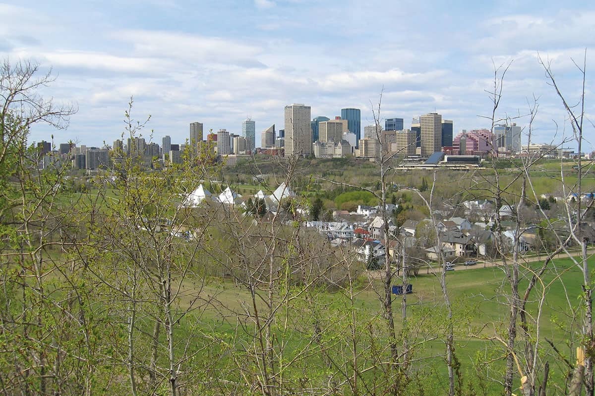
The Camel Humps natural area is located in the Cloverdale neighbourhood. It starts just off the North Saskatchewan River and climbs right up to the edge of the riverbank. From end to end, the area features a diverse mix of small hills, canyons, woodlands, and winding trails.
A century ago, the river valley rose smoothly and evenly from the floodplain. It hadn’t changed much since a raging river carved it out at the end of the last Ice Age, roughly 12,000 years ago. But around 1905, when Alberta officially became a province, the riverbank underwent a massive transformation. This process reshaped the terrain, ultimately giving it the distinctive look that earned it the name “The Camel Humps.”
From the Ice Age to Brick Manufacturing
People discovered sandy deposits along certain stretches of the riverbank—likely left behind by ancient rivers. At the same time, lime was being brought in via the newly built railway lines. These two materials were perfect for making sand-lime bricks. Unlike traditional red baked bricks, these were incredibly durable and practically sold themselves during Edmonton’s first major construction boom.
The Edmonton Pressed Brick Company jumped on this opportunity. They bought a section of the riverbank from Cornelius Gallagher, a man who owned a meatpacking plant and plenty of land in Cloverdale. Today, just across Cloverdale Hill Road from The Camel Humps, Gallagher Park (home to the annual Edmonton Folk Music Festival) bears his name.
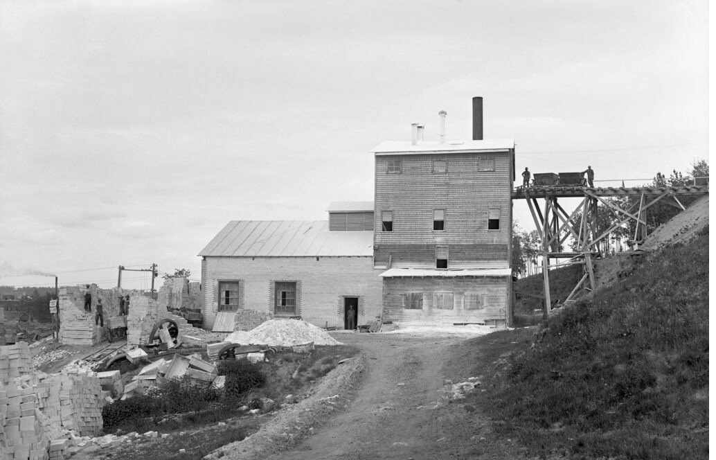
The brick plant rolled out its first batch in 1908. At its peak, the facility was churning out up to 30,000 bricks a day, and initially, business was booming. Interestingly, the plant had previously made its money by mining, shipping, and selling sand. It was this intense sand mining that ultimately gave The Camel Humps their signature shape. The factory employed a large crew and relied on a variety of heavy machinery. Steam and electric power drove the mixers and pressed the sand-lime mixture into the moulds that shaped the bricks.
Workers mined the riverbank sand by hand using nothing but shovels. It was grueling physical labour, but the plant was at least designed to use gravity to its advantage. The mining happened on the hillside above the factory, and the sand was funneled down. Once the bricks were made, they were loaded even further down the hill onto railcars or sturdy horse-drawn wagons to be shipped off to customers.
Edmonton-made bricks were used to build many structures that are still standing today, including stately homes, schools, and hospitals. The brickyard saw massive growth in 1912 when it was bought out by the Hardstone Brick Company, headed by Gallagher himself. However, June 18, 1915, marked the last day of production at the Hardstone plant. Newspapers at the time were entirely focused on the battlefields in France and Alberta’s Prohibition referendum, so the factory’s closure barely made the news.
Another major distraction hit just 10 days later: the North Saskatchewan River flooded. The water levels surged, breaching the banks and inundating the floodplain settlements. Before long, nature reclaimed the riverbank. Topsoil that had been stripped away and piled into high mounds near the mining pits eventually sprouted new shrubs and trees. Over time, the landscape transformed into the densely forested area we see today. Now, these hills, dips, and thick greenery provide a perfect sanctuary for local wildlife. It’s common to spot squirrels and birds, and coyotes and jackrabbits likely live secret lives hidden in the underbrush.
Kathryn Ivany, the head archivist at the City of Edmonton Archives, suggests the name likely comes from two prominent hills that naturally look like camel humps. There’s also a local legend about a woman living in the area during the 1980s. She supposedly first heard the name from her sons, who came home laughing about tobogganing down the “Camel Humps” nearby. Whatever the true origin, it’s a beloved unofficial name used strictly by the locals.
What to See at The Camel Humps
The trails winding through The Camel Humps are twisting and intricate, with trees and rolling hills often blocking your view of what’s ahead. In one particular spot, three trails run parallel to each other, separated by only about 10 metres. But because the slope is so steep, they actually sit on three completely different elevations, each leading off in its own direction.
For generations, The Camel Humps has been considered a magical, mysterious place where local kids have experienced countless outdoor adventures. That sense of mystery and unique character is still very much alive today.
The Camel Humps draws visitors looking for:
- Sweeping views of the river valley and forests.
- A secluded, peaceful atmosphere.
- Excellent conditions for hiking and casual walks.
- Great opportunities for wildlife spotting.
Ultimately, The Camel Humps is a fantastic spot for anyone looking for a quiet outdoor escape close to Edmonton, perfect for soaking in some much-needed peace and nature.